This hike to Lake Hochgränten follows the Carnic Ridge via the Sillian Mountain Hut, directly below the Hollbruck Peak
Image gallery: Hike from the Leckfeld Hut to the Hochgräntenjoch


The Leckfeld Mountain Hut (Leckfeldalm) is the starting point for our hike to the Hochgräntenjoch, a mountain pass on the Carnic High Route (Karnischer Höhenweg). We reach the car park at the mountain hut via a toll road from Sillian. Our hike begins up here, at about 1,900 metres above sea level. We first walk along a farm track (no. 471) to the Leckfeld Saddle. This is already situated on the border ridge, which opens up views of the Sesto Dolomites. A few minutes later, we reach the Sillian Mountain Hut at 2,455 m a.s.l., the only rest point on our route.
We continue southeast on trail no. 403 (Carnic High Route), passing old border fortifications below Mt. Hochgrubenspitze. We then cross the Obermahd Saddle at 2,466 metres a.s.l. and continue beneath the Hornischegg towards the Hollbruck Peak. The two Hollbruck Lakes shimmer below our path. The views on the western side extend from the Sesto Dolomites, with Mt. Croda Rossa, Mt. Punta dei Tre Scarperi and the Three Peaks of Lavaredo, to the Val Pusteria valley in South Tyrol in Italy. To the east, our gaze sweeps across the Lesach Valley to the Lienz Dolomites, also known as the Gailtal Alps, and to the High Tauern in the north.
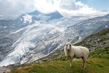
The summit of the Hollbruck Peak is bypassed on the South Tyrolean side. Then the high trail switches back to the East Tyrolean side, leading to our destination: the Hochgräntenjoch. Here, our path intersects with trails to the Nemes Mountain Hut on the Italian side and to Hollbruck on the Austrian side. Lake Hochgränten lies directly at the pass, with the almost 2,600-metre-high Muta (Demutspitze) visible behind it. Cows graze peacefully in the alpine meadows.
Around the lake, we are also reminded of dramatic times. The war cemetery, along with the remains of barracks and dugouts, illustrate how fiercely contested this border was during the First World War, resulting in heavy casualties. How fortunate that these times are over and we can now enjoy the landscape and nature here. Although we've only covered a few kilometres of the total 150 km Carnic High Route on this hike, we've gained a glimpse into the beauty of this lesser-known area.
To return to our starting point, we retrace our steps. Views of the Hochpustertal and its Italian part, the Upper Val Pusteria, and to the Three Peaks of Lavaredo complete the hiking experience.
Author: AT
-
- Starting point:
- Leckfeld Alm parking space (toll road from Sillian, 4€)
-
- Time required:
- 05:45 h
-
- Track length:
- 12,9 km
-
- Altitude:
- from 1.916 m to 2.545 m
-
- Altitude difference:
- +752 m | -752 m
-
- Route:
- Leckfeldalm - Sillianer Hütte - Hochgräntenjoch
-
- Signposts:
- No. 471 (Leckfeldsattel), 403
-
- Destination:
- Hochgräntenjoch
-
- Resting points:
- Sillaner Hütte mountain hut
-
- Recommended time of year:
- Jan Feb Mar Apr May Jun Jul Aug Sep Oct Nov Dec
-
- Download GPX track:
- Hike from the Leckfeld Hut to the Hochgräntenjoch
If you want to do this hike, we suggest you to check the weather and trail conditions in advance and on site before setting out.